 Mixing

Alberta Highway 93
Highway 93 | ||||
|---|---|---|---|---|
Banff-Windermere Highway Icefields Parkway | ||||
 | ||||
| Route information | ||||
| Length | 268 km (167 mi) | |||
| Existed | 1940 – present | |||
| Restrictions | No commercial vehicles and National Parks pass required along the Icefields Parkway. | |||
| Major junctions | ||||
| South end | ||||
| North end | ||||
| Location | ||||
| Specialized and rural municipalities | I.D. No. 9, I.D. No. 12, Jasper | |||
| Highway system | ||||
Provincial highways in Alberta
| ||||

Highway 93 is a north-south highway in Alberta, Canada. It is also known as the Banff-Windermere Parkway south of the Trans-Canada Highway (Highway 1) and the Icefields Parkway north of the Trans-Canada Highway. It travels through Banff National Park and Jasper National Park and is maintained by Parks Canada for its entire length.[1] It runs from the British Columbia border at Vermilion Pass in the south, where it becomes British Columbia Highway 93, to its terminus at the junction with the Yellowhead Highway (Highway 16) at Jasper.[2] The route takes its number from U.S. Route 93, which runs uninterrupted south to central Arizona, and was initially designated as ‘93’ in 1959.
Contents
1 Route description
1.1 Banff-Windermere Highway
1.2 Trans-Canada Highway
1.3 Icefields Parkway
2 Major intersections
3 Highway 93A
4 Gallery
5 References
6 External links
Route description
Banff-Windermere Highway

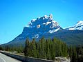
Castle Mountain, in Banff National Park, as seen from Highway 93.
The southern portion of the route is part of the Banff-Windermere Highway, a 104 km (65 mi) highway that travels from British Columbia Highway 95 at Radium Hot Springs, through Kootenay National Park and Vermilion Pass across the Continental Divide, to the junction of the Trans-Canada Highway (Highway 1) at Castle Junction.[3] The final 10 km (6.2 mi) of the highway are in Alberta and Banff National Park. Prior to 1959, the highway was designated as Highway 1B.[4]
Trans-Canada Highway
Highway 93 connects with the Trans-Canada Highway (Highway 1) at Castle Junction, midway between Banff and Lake Louise.[3] Highway 93 follows the Trans-Canada Highway for 28 km (17 mi) northwest, diverging from highway 1 west of Lake Louise. Highway 1 continues west to Yoho National Park. The Bow Valley Parkway (Highway 1A) also links Lake Louise and Banff. This road parallels Highway 1 and, at the midpoint, passes Castle junction where it links with Highway 93.[3]
Icefields Parkway
@media all and (max-width:720px).mw-parser-output .tmulti>.thumbinnerwidth:100%!important;max-width:none!important.mw-parser-output .tmulti .tsinglefloat:none!important;max-width:none!important;width:100%!important;text-align:center

The Icefields Parkway (French: Promenade des Glaciers), is a 230 km (140 mi) long scenic road that parallels the Continental Divide, traversing the rugged landscape of the Canadian Rockies, travelling through Banff National Park and Jasper National Park. It is named for features such as the Columbia Icefield, visible from the parkway. It links Lake Louise with Jasper to the north. At its southern end, the Icefields Parkway terminates at Highway 1. Highway 1 west leads to Yoho National Park in British Columbia and Highway 1 east to Lake Louise and the Town of Banff. A second parkway, the Bow Valley Parkway also links Lake Louise and the Town of Banff. Known as Highway 1A, this road parallels Highway 1 and, at the midpoint, passes the Castle Mountain junction where Highway 93 south, or the Banff-Windermere Highway, branches southwest into Kootenay National Park in British Columbia.[3]
The Icefields Parkway was predated by the Glacier Trail, which opened in 1885 after the Canadian Pacific Railway was completed and brought increased tourist traffic to Banff National Park. In 1931, the federal government commissioned the construction of a single-track road between Lake Louise and Jasper as a Great Depression as a relief project. In order to employ as many people as possible, the road was constructed by hand and employed 600 men.[5] The road was completed in 1940; however, the 1950s saw an increase in automobile use and increased traffic along the parkway. In 1961, a reconstructed paved and modern highway was opened.[5]
The parkway is busy in July and August with up to 100,000 vehicles a month. The parkway is mainly two lanes with occasional passing lanes. It minimizes grades and hairpin turns but travellers must look out for wildlife, and vehicles stopped on the shoulder. Snow can be expected at any time of year and extreme weather is common in winter.
A Canadian national parks permit is required to travel on the Icefields Parkway; stations near Lake Louise and Jasper enforce the law. Commercial trucks are prohibited.[6] The speed limit is 90 km/h (55 mph) although the limit is reduced at Saskatchewan River Crossing and the Columbia Icefield area. In winter, chains or winter-rated radial tires are required by law and road closures may occur without warning. There is no cell coverage.[7]
Major intersections
Starting from the south end of Highway 93:
| National Park | Location | km | mi | Destinations | Notes |
|---|---|---|---|---|---|
British Columbia border | 0.0 | 0.0 | Vermilion Pass – 1,680 m (5,510 ft) — 51°13′44″N 116°03′02″W / 51.228776°N 116.050600°W / 51.228776; -116.050600 (Vermilion Pass) | ||
| Banff | | 10.0 | 6.2 | Hwy 93 branches northwest; south end of Hwy 1 concurrency 51°15′52″N 115°55′56″W / 51.264565°N 115.932311°W / 51.264565; -115.932311 (TCH 1 east) | |
| North end of Banff-Windermere Highway | |||||
| 32.5 | 20.2 | Crosses the Bow River — 51°24′08″N 116°09′32″W / 51.402339°N 116.159023°W / 51.402339; -116.159023 (Bow River) | |||
| Lake Louise | 35.5 | 22.1 | 51°25′34″N 116°10′24″W / 51.426110°N 116.173373°W / 51.426110; -116.173373 (Lake Louise) | ||
| | 38.2 | 23.7 | Hwy 93 branches north; North end of Hwy 1 concurrency 51°26′29″N 116°12′04″W / 51.441419°N 116.201168°W / 51.441419; -116.201168 (TCH 1 west) | ||
Icefields Parkway begins • National Park pass required | |||||
| 38.9 | 24.2 | Park gate | 51°26′40″N 116°12′33″W / 51.444582°N 116.209127°W / 51.444582; -116.209127 (South Park Gate) | ||
| 71.0 | 44.1 | Crowfoot Glacier (roadside pullout) | 51°39′50″N 116°26′23″W / 51.663857°N 116.439681°W / 51.663857; -116.439681 (Crowfoot Glacier) | ||
| 73.5 | 45.7 | unnamed road – Bow Lake | 51°40′56″N 116°27′43″W / 51.682351°N 116.461960°W / 51.682351; -116.461960 (Bow Lake) | ||
| 78.4 | 48.7 | Bow Summit – 2,069 m (6,788 ft) | |||
unnamed road – Peyto Lake | 51°43′12″N 116°29′41″W / 51.719901°N 116.494699°W / 51.719901; -116.494699 (Bow Summit) | ||||
| 108.8 | 67.6 | Mistaya Canyon (roadside pullout) | 51°56′28″N 116°43′02″W / 51.941084°N 116.717254°W / 51.941084; -116.717254 (Mistaya Canyon) | ||
| 112.4 | 69.8 | Crosses the North Saskatchewan River — 51°58′14″N 116°43′13″W / 51.970431°N 116.720373°W / 51.970431; -116.720373 (N Sask River) | |||
| Saskatchewan River Crossing | 114.0 | 70.8 | 51°58′24″N 116°44′35″W / 51.973260°N 116.742946°W / 51.973260; -116.742946 (Hwy 11) | ||
| | 149.6 | 93.0 | Parker Ridge (roadside pullout) | 52°10′37″N 117°03′22″W / 52.177048°N 117.055986°W / 52.177048; -117.055986 (Parker Ridge) | |
| ↑ / ↓ | | 159.1 | 98.9 | Sunwapta Pass – 2,030 m (6,660 ft) — 52°12′50″N 117°09′49″W / 52.213759°N 117.163609°W / 52.213759; -117.163609 (Sunwapta Pass) | |
| Jasper | Columbia Icefield | 163.5 | 101.6 | Icefields Centre, Athabasca Glacier | 52°13′11″N 117°13′29″W / 52.219679°N 117.224859°W / 52.219679; -117.224859 (Columbia Icefield) |
| | 211.9 | 131.7 | unnamed road – Sunwapta Falls | 52°32′13″N 117°38′28″W / 52.537049°N 117.641038°W / 52.537049; -117.641038 (Sunwapta Falls) | |
| 235.3 | 146.2 | 52°40′08″N 117°52′54″W / 52.668965°N 117.881529°W / 52.668965; -117.881529 (Athabasca Falls) | |||
| 257.9 | 160.3 | Crosses the Athabasca River — 52°48′43″N 118°02′28″W / 52.811830°N 118.041064°W / 52.811830; -118.041064 (Athabasca River) | |||
| 258.7 | 160.7 | 52°48′51″N 118°03′02″W / 52.814144°N 118.050557°W / 52.814144; -118.050557 (Hwy 93A) | |||
| 259.2 | 161.1 | Park gate | 52°49′07″N 118°03′10″W / 52.818584°N 118.052744°W / 52.818584; -118.052744 (North Park Gate) | ||
| 263.6 | 163.8 | Whistlers Road – Jasper Skytram | 52°51′16″N 118°04′41″W / 52.854548°N 118.077977°W / 52.854548; -118.077977 (Whistlers Rd) | ||
| 264.0 | 164.0 | 52°51′30″N 118°04′46″W / 52.858376°N 118.079377°W / 52.858376; -118.079377 (Hwy 93A) | |||
| 264.7 | 164.5 | Crosses the Miette River — 52°51′45″N 118°05′11″W / 52.862593°N 118.086487°W / 52.862593; -118.086487 (Miette River) | |||
| Jasper | 265.4 | 164.9 | Icefields Parkway ends | ||
Connaught Drive – Jasper | Hwy 93 ends 52°52′00″N 118°05′36″W / 52.866548°N 118.093284°W / 52.866548; -118.093284 (TCH 16) | ||||
1.000 mi = 1.609 km; 1.000 km = 0.621 mi
| |||||
Highway 93A
Highway 93A | |
| Location | Jasper National Park |
| Southern section | |
| Length | 24 km (15 mi) |
| South end | |
| North end | |
| Northern section | |
| Length | 1.7 km (1.1 mi) |
| South end | |
| North end | |
Just south of Jasper, a short spur of the parkway branches off as Highway 93A, providing access to businesses on the south side of Jasper and providing an alternative route into the community via Hazel Avenue. Another Highway 93A spur farther south is 24 km (15 mi) long, is along Highway 93 and provides alternative access to viewpoints and other attractions within Jasper National Park.
Highway 93A south of Jasper is narrow and the pavement uneven, with an average limit of 60 km/h (37 mph). Brush grows up to the side of the highway so animals can be difficult to see.
Gallery

Icefields Parkway

Icefields Parkway
Icefields Parkway

Icefields Parkway
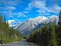
Icefields Parkway

Icefields Parkway
Icefields Parkway

Icefields Parkway

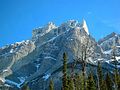
Crowfoot Mountain


References
^ "Internal Audit and Evaluation Documents: Evaluation of Parks Canada's Through Highway Management". Parks Canada. November 22, 2010. Retrieved June 22, 2016.
^ Alberta Official Road Map (Map) (2015 ed.). City of Edmonton Transportation Services for Alberta Culture and Tourism. § J–2, K–3, L–3, and L–4.
^ abcd Google (October 23, 2017). "Highway 93 in Alberta" (Map). Google Maps. Google. Retrieved October 23, 2017.
^ "Shell British Columbia-Alberta Highway Map". David Rumsey Map Collection. The H.M. Gousha Company. 1956. Retrieved June 23, 2016.
^ ab "A brief history of the Icefields Parkway - Jasper National Park". Parks Canada Agency. Government of Canada. June 1, 2017. Archived from the original on July 23, 2017. Retrieved October 23, 2017.
^ "Banff National Park - Park Passes". Parks Canada. Government of Canada. December 3, 2014. Archived from the original on April 20, 2016. Retrieved April 26, 2016.
^ "Icefields Parkway - Banff National Park". Parks Canada. Government of Canada. April 1, 2017. Archived from the original on September 19, 2017. Retrieved October 23, 2017.
External links
| Wikimedia Commons has media related to Icefields Parkway. |
| Wikivoyage has a travel guide for Icefields Parkway. |
- Banff National Park - Icefields Parkway
- Jasper National Park - Icefields Parkway
- Icefield Parkway.ca
- Travel Alberta - Icefields Parkway

 Clash Royale CLAN TAG#URR8PPP
Comments
Post a Comment