 Mixing

Big Wood River
| Big Wood River | |
| River | |
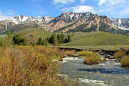 Big Wood River and Boulder Mountains | |
| Country | United States |
|---|---|
| State | Idaho |
| Regions | Blaine County, Lincoln County, Gooding County |
Tributaries | |
| - left | North Fork Big Wood River, East Fork Wood River |
| - right | Camas Creek (Big Wood River) |
| Cities | Sun Valley, Ketchum |
| Source | Sawtooth Range |
| - location | Galena Summit, Blaine County |
| - elevation | 9,100 ft (2,774 m) [1] |
| - coordinates | 43°51′38″N 114°42′48″W / 43.86056°N 114.71333°W / 43.86056; -114.71333 [2] |
| Mouth | Malad River |
| - elevation | 3,460 ft (1,055 m) [1] |
| - coordinates | 42°56′42″N 114°47′44″W / 42.94500°N 114.79556°W / 42.94500; -114.79556Coordinates: 42°56′42″N 114°47′44″W / 42.94500°N 114.79556°W / 42.94500; -114.79556 [2] |
| Length | 137 mi (220 km) [3] |
| Discharge | for below Magic Reservoir |
| - average | 464 cu ft/s (13.14 m3/s) [4] |
| - max | 9,800 cu ft/s (277.51 m3/s) |
| - min | 0 cu ft/s (0.00 m3/s) |
The Big Wood River is a 137-mile-long (220 km)[3]river in central Idaho. It is a tributary of the Malad River, which in turn is tributary to the Snake River and Columbia River.
Contents
1 Course
2 See also
3 Notes
4 References
Course
From its source in the Sawtooth Range near Galena Summit in the Sawtooth National Recreation Area, the Big Wood River generally flows south, between the Boulder Mountains to the north, Pioneer Mountains to the east, and the Smoky Mountains to the west. Highway 75 accompanies the river southward from Galena Summit, to an area north of Shoshone.
The river flows by Sun Valley and Ketchum, where it receives the tributary streams of Warm Springs Creek and Trail Creek. Below Ketchum, it is joined by the East Fork Wood River at Gimlet before passing by the small cities of Hailey and Bellevue. Continuing south, the river enters the Wood River Valley, the northern part of Magic Valley, after which it flows into Magic Reservoir. A tributary stream, Camas Creek,[Note 1] joins the river in Magic Reservoir.
Below Magic Dam, the Big Wood River enters Lincoln County, passing by many lava beds and irrigation canals before entering Gooding County. Just west of Gooding, the Big Wood River joins the Little Wood River to form the Malad River.
Big Wood River's water flow is affected by numerous irrigation reservoirs and canals on the river itself and its tributaries.
Variant names of the Big Wood River, according to the USGS, include Malad River, Malade River, Wood River, Poisonous Beaver River, and Sickley River.[2]
See also
- List of Idaho rivers
- List of longest streams of Idaho
Notes
^ One of the tributaries of the Camas Creek which flows into the Big Wood River (not to be confused with at least four other Camas Creeks in Idaho). One of the tributaries of that Camas Creek is called the Malad River. What makes that interesting is that the Big Wood River empties into the Malad River, thus making the Malad River and tributary of the Malad River.
References
^ ab Google Earth elevation for GNIS coordinates
^ abc "Big Wood River". Geographic Names Information System. United States Geological Survey.
^ ab U.S. Geological Survey. National Hydrography Dataset high-resolution flowline data. "The National Map". Archived from the original on 2012-04-05. , accessed May 4, 2011
^ "Water Resource Data, Idaho, 2005". , USGS.

 Clash Royale CLAN TAG#URR8PPP
Comments
Post a Comment